"… I seem […] only like a boy playing on the sea-shore, and diverting myself in now and then finding a smoother pebble or a prettier shell than ordinary, whilst the great ocean of truth lay all undiscovered before me". – Isaac Newton.
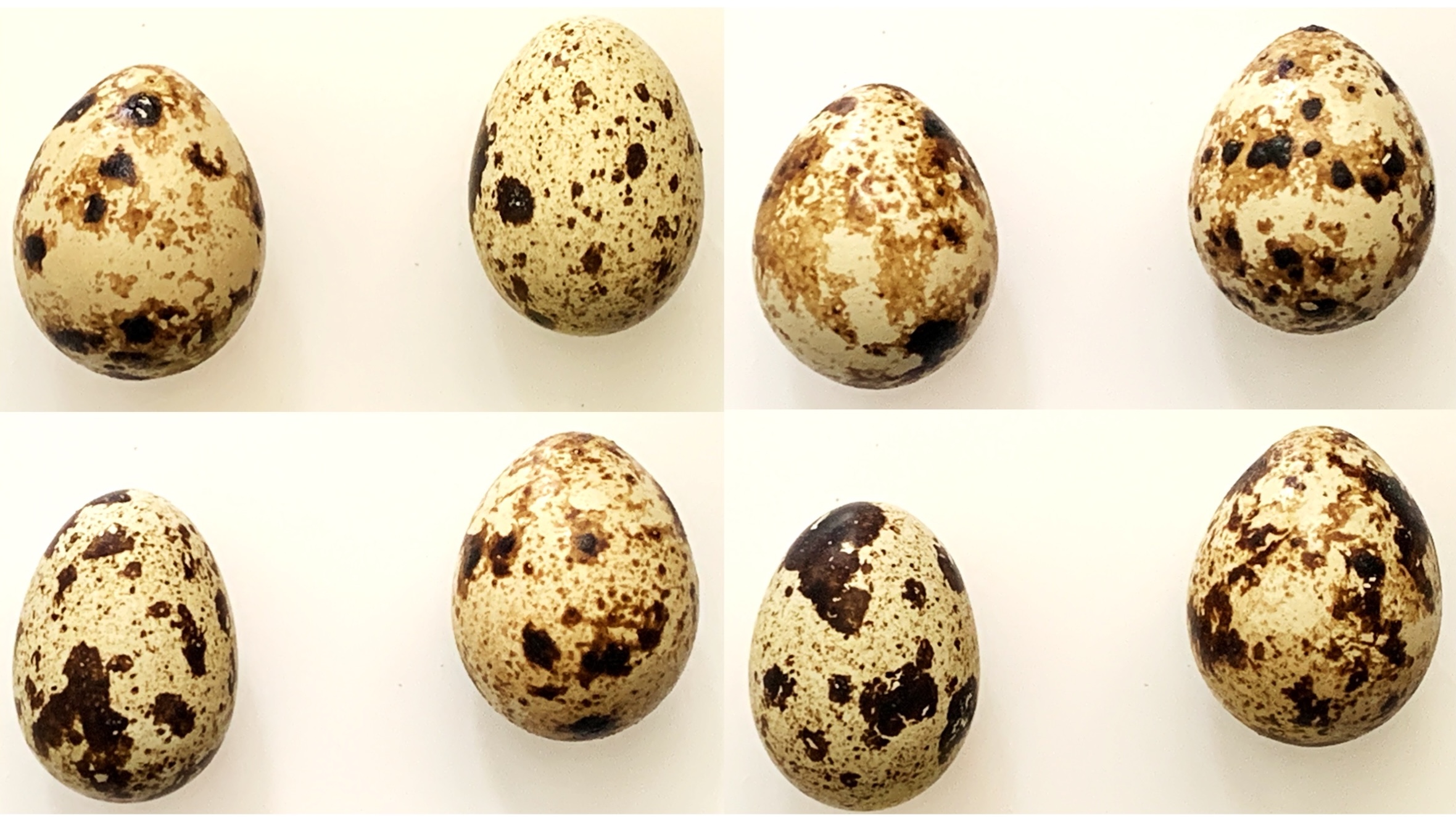
Last year, after a series of unsuccessful attempts and acquiring three incubators across two countries, my youngest son’s unwavering determination finally paid off. From a batch of twelve mixed quail eggs, seven hatched successfully, marking the start of our new venture into farm animal husbandry. Currently, we’ve settled for manageable pets like a Siberian hamster, an aquarium, and pond fish, plus several rounds of stick insects, mantises, and spiders, along with their grasshopper and locust food supplies. However, quail care is more demanding. While our sons’ happiness is undoubtedly the most important reward, the delicious eggs produced by our farm breeding activity are equally rewarding for the whole family. It’s particularly satisfying collecting every evening the two expected eggs from the punctual quail hens and admiring their different sizes and pigmentation like beautiful little gems.
If you’re still reading, you’ve probably guessed the main topics of my traditional Easter blog: quail eggs and their shapes and patterns.
Boundary value problems (BVPs) for ordinary differential equations arise naturally in many areas of physics, engineering, and applied mathematics. Classical examples include the vibration of strings, heat conduction in solids, and quantum mechanical bound states. Unlike initial value problems (IVPs), where all conditions are specified at a single point, BVPs impose constraints at different points of the domain, making them significantly more challenging to solve both analytically and numerically.
The shooting method is one of the most intuitive and historically rooted techniques for tackling such problems. Its central idea is simple: transform a boundary value problem into an initial value problem by guessing the missing initial conditions, then iteratively refine this guess until the solution satisfies the boundary conditions at the other end. The method is often illustrated through a ballistic analogy—one “shoots” from the initial point and adjusts the trajectory until the target is hit. Although the shooting method was formalized only in the 20th century, its conceptual foundations can be traced back much earlier. The study of differential equations in the 18th and 19th centuries by mathematicians such as Leonhard Eulerand Joseph-Louis Lagrange already revealed the difficulty of boundary value problems in mechanics and astronomy. At that time, analytical solutions were often unavailable, and practitioners relied on approximation strategies that implicitly resembled “trial-and-error” approaches. A decisive step toward the modern shooting method came with the development of reliable numerical solvers for initial value problems around 1900, notably through the work of Carl Runge and Martin Kutta. Their methods provided the computational backbone needed to integrate differential equations accurately from a given starting point. This made it feasible to implement the idea of repeatedly “shooting” with different initial guesses. The method gained wider recognition and systematic treatment in the mid-20th century, alongside the emergence of numerical analysis as a distinct discipline. Influential mathematicians such as Richard Courant contributed to the theoretical understanding of boundary value problems, while the increasing availability of digital computers transformed the shooting method into a practical and widely used computational tool.
Today, the shooting method remains a cornerstone in the teaching of numerical methods due to its conceptual clarity and direct connection to physical intuition. While more robust techniques—such as finite difference and finite element methods—are often preferred for complex or stiff problems, the shooting method continues to play an important role in applications ranging from classical mechanics to quantum physics, where it is frequently used to determine eigenvalues and admissible solutions.
In this blog, I will give an example of the application of the method to the solution of the Thomas-Fermi and Thomas-Fermi-Dirac equations.
The Smoluchowski diffusion equation describes the time evolution of the probability density function (PDF) of a particle undergoing overdamped Brownian motion in a potential energy landscape. It is a central equation in statistical mechanics, soft matter physics, and chemical physics.
Its origins trace back to the early 20th century, in the context of the theoretical understanding of Brownian motion. Following the seminal work of Albert Einstein in 1905, who provided a statistical description of diffusion and established a quantitative link between microscopic fluctuations and macroscopic transport, further developments aimed to incorporate external forces and interactions. In 1916, Marian Smoluchowski extended Einstein’s framework by considering particles subjected to systematic forces arising from a potential field. His formulation led to what is now known as the Smoluchowski equation, effectively describing diffusion in the overdamped (high-friction) limit where inertial effects can be neglected. This marked a crucial step toward connecting stochastic motion with deterministic drift. A complementary perspective emerged through the work of Paul Langevin (1908), who introduced a stochastic differential equation for particle motion, explicitly incorporating random forces. The equivalence between the Langevin description and the corresponding evolution equation for probability densities—later formalized as the Fokker–Planck equation—provided a deep and unifying framework. The general mathematical structure of such evolution equations was further clarified by Adriaan Fokker and Max Planck in the early 20th century, leading to the modern formulation of the Fokker–Planck equation. The Smoluchowski equation can be viewed as a specific limit of this more general framework. Later, in the 1940s, Hendrik Anthony Kramers applied these ideas to chemical reaction rates, analyzing barrier crossing in potential landscapes. His work revealed how transition rates depend exponentially on the energy barrier height, establishing the foundation of what is now known as Kramers’ theory—an essential concept for understanding metastability and rare events.
In this article, we consider the one-dimensional (1D) case, where a particle moves along a coordinate under the influence of a potential of mean force .
In previous posts on this blog I have already introduced the Fourier series and the Fourier transform, following their historical development from Joseph Fourier’s original work on heat conduction to their modern role in physics, engineering, and signal analysis. Rather than repeating that material here, I will take it as a starting point.
When we look at a signal — a sound wave, a vibration, or even a curve drawn by hand — we usually perceive it as a function of time or space. However, very often the most relevant information is not immediately visible in this representation. It is hidden in the frequencies that compose the signal, and in how strongly each of them contributes.
This is precisely the idea behind the Discrete Fourier Transform (DFT): to decompose a discrete signal into a finite sum of harmonic components, each characterized by an amplitude and a phase. Conceptually, the DFT is not a new theory, but a practical bridge between the continuous Fourier framework and the realities of digital data, measurements, and numerical simulations.
Rather than starting from abstract formulas, in this post I adopt a visual and experimental approach. The discussion is supported by an interactive program that allows one to draw an arbitrary signal and explore its harmonic content, and by a practical electronics project where Fourier analysis is applied to real sound and noise signals.
Quest’anno ricorre l’anniversario della pubblicazione dell’articolo di Edwin Schrödinger (1887-1961) in cui viene introdotta la sua famosa equazione. Prendendo spunto da questa occasione, ho ripescato e rinnovato uno dei miei antichi progetti di programmazione in BASIC con i miei microcomputer negli anni ’80. Di nuovo il microcomputer era il mio amato Phillips MSX, di cui ho parlato in altri blog. Studiando chimica, non potevo non essere attratto dalla bellezza e dall’eleganza delle soluzioni dell’equazione di Schrödinger per l’atomo d’idrogeno. Inspirato dal libro (S. Marseglia, La Chimica col personal computer pubblicato dalla Muzzio) in cui mostrava alcuni esempi di programmi in BASIC per la chimica, decisi di imbarcarmi nell’impresa e usare l’MSX e poi l’Amiga Basic Basic per provare a riprodurre le bellissime visualizzazioni degli orbitali molecolari che vedevo nei libri di chimica universitari. Ma prima di questo vediamo di tornare a contenuto dell’articolo di Schrödinger.
Christmas is a time for traditions, decorations, and—at least for some of us—quiet moments spent playing with ideas. In that spirit, this post is a small seasonal diversion: a recreational exploration of large factorial numbers, their historical computation, and an unusual way to see them. The inspiration comes from an old but delightful article by the great recreational mathematician Martin Gardner, titled “In which a computer prints out mammoth polygonal factorials” (Scientific American, August 1967), in which he discusses the astonishing growth of the function
and the surprising difficulty computers once faced when trying to compute it for even modest values of n.
In this post, I will briefly describe the Smith bin algorithm for computing large factorials and present the result for the number 2025, arranged in a geometric form. After all, if numbers are going to grow explosively, why not let them grow into Christmas trees for 2025?
Alatri is a picturesque town in the province of Frosinone, 80 km southeast of Rome. Located in the heart of Ciociaria, it overlooks the Sacco Valley from the highest point on top of a hill. Among other important attractions, the historical center of the city treasures one of the best-preserved megalithic constructions in Ciociaria. Megalithic architecture is characterized by imposing stonework (also called megalithic or Cyclopean ruins). The one in Alatri is an impressive perimeter wall. The wall, known as the polygonal walls, is built around the highest point of the town, the acropolis. It was constructed for fortification and ritual worship purposes. The megalithic civilization reached the highest level of stone masonry during the Neolithic period. Major centers existed in different Italian regions and throughout Europe from Greece to England. Alatri is just one of the megalithic towns of Ciociaria. Other nearby impressive remains can be found in Ferentino and Veroli.
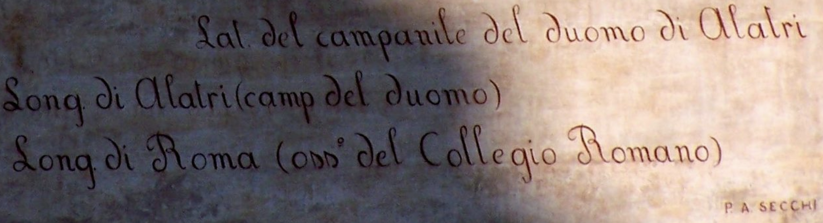
I will write more about megalithic architecture in another article. In this context, I will describe a more recent but still beautiful architectural embellishment. This embellishment has a practical function. It is prominently visible in the Piazza Santa Maria Maggiore, the town’s central square. I am referring to the beautiful sundial (OROLOGIO SOLARE in italiano, see photo below). It was built in 1867 on the facade of the Palazzo Conti Gentili. The architect Giuseppe Olivieri constructed it based on accurate calculations by Padre Angelo Secchi. He was a renowned Jesuit and astronomer. A photo of the sundial is reported below. In Italian, the sundial is translated as orologio solare, as written in the image.
Figure 1: Photo of the Secchi’s sundial located in Piazza Santa Maria Maggiore of Alatri.
The analysis of this sundial gave me the opportunity to introduce the principles used to build it. I also learned a bit more about astronomical calculations. Therefore, I want to share with the reader my findings.
What is a sundial?
The sundial (also called meridian) is a time-measuring device based on the regular rotation of the Earth. The Sun’s apparent position in the sky changes the shadow’s projection cast by the dial. This shadow falls on a surface that has been time marked. As a result, the surface can have different orientations and shapes. The Secchi’s sundial is a vertical type with orientation North-South. The title on the top states this: The Secchi’s sundial shows the real time. It also shows the average time (OROLOGIO SOLARE A TEMPO VERO E MEDIO). The calligraphic text on the bottom indicates the geographic coordinates of the sundial.
The latitude and longitude indicate the location of the bell tower. It is part of the cathedral of Alatri (duomo di Alatri o Basilica di San Paolo). As reference meridian (the prime meridian) was consider the one passing for the city of Rome. In particular, it is the meridian that passes through the Collegio Romano observatory. Secchi was the director there at the time of the sundial’s construction. The international adoption of the prime meridian passing through London was agreed upon during an international geographic conference. This conference was organized in the same city in October 1884. Before this date, country were used to adopt their own prime meridian, usually passing for the capital. So it is not surprising that Sacchi used as reference meridian the one passing for Rome. The Colleggio Romano was a school established by founder of the Society of Jesus St. Ignatius of Loyola in 1551. It is located in the Piazza del Collegio Romano in the Pigna District. P.A. Secchi was the director of the astronomic observatory of the school. The Monte Mario Observatory was constructed in 1934, at Villa Mellini. This moved the prime meridian for Rome there. It was used as the reference meridian for Italy’s geographic maps until 1960.
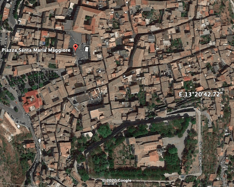
The geographic coordinates of the cathedral of Alatri given by Google Maps are 41.7248° N, 13.3443° E. Therefore, Sacchi approximated the longitude to the one of the Collegio Romano (41.8988° N, 12.4807° E) that he could accurately calculate. According to Google Earth, the sundial’s position is 41°43′ 35.86″ N, 13° 20′ 33.86″ E. Therefore, the prime meridian is used to calculate the real-time of the sundial.
Figure 2: Position of the Piazza Santa Maria Maggiore and of the cathedral of Alatri (bottom complex). Source Google Earth.
The length of the shadow cast by the sundial varies with the Sun’s altitude, and it also changes during the year as the Earth moves along an orbit that is inclined by ~23.4° concerning the ecliptic plane (the position of the Sun’s equator). The length defines a particular position for the Earth in its orbit, as the solstices and equinoxes are the dates in between. The length of the shadow is marked on the solar clock with seven declination arcs. The latter ones go from left to right, delimited by the Zodiac signs and solstices, and equinoctial dates. Using the Zodiac sign is a convenient way to divide into 12 sectors of 30° the ecliptic longitude along the Earth’s orbit. This leads to 7 arcs, five crossed twice by the Sun (when its declination is increasing and decreasing), plus two for solstices (extreme declinations). As Sun’s altitude varies between +/- 23° 26′, it is also possible to draw arcs every 5° of declination, with the equinoctial line (March 21st and September 22nd) in the middle which corresponds to 0° of declination (Sun on the equator).
Description of the Components of the Sundial
The Secchi’s sundial in Alatri consists of several key components that contribute to its functionality and accuracy in measuring time. These components include the gnomon, the dial plate, the hour lines, and the declination arcs. The dial plate serves as the surface upon which the shadow of the gnomon falls. It is typically a flat, horizontal surface with markings or engravings that denote the hours of the day. In the case of this sundial, the dial plate features hour lines and declination arcs that aid in reading the time and understanding the position of the Sun.
Gnomon: The gnomon is a crucial element of the sundial, responsible for casting the shadow that indicates the time. In the case of the Secchi’s sundial, the gnomon is a vertical structure aligned in a North-South direction. It is designed to be perpendicular to the dial plate and is carefully positioned to ensure the accuracy of the shadow projection.
Hour Lines: The hour lines on a vertical sundial represent the hours of the day and are usually spaced evenly on the dial plate. To determine the position of the hour lines, we consider the angle between the gnomon and the noon line (the line pointing directly towards the Sun at solar noon). Let’s denote this angle as θ. Assuming that the gnomon is aligned perfectly North-South, the angle θ can be calculated using the latitude of the sundial’s location (represented by φ). The equation is as follows: Once we have the angle , we can divide it by (since there are 15 degrees of longitude per hour) to determine the angular distance between each hour line.This angular distance can then be translated into linear distances on the dial plate based on the specific design of the sundial. In Secchi’s sundial, the lines are indicated with Roman numerals from left to right as X, XI, XII, I, II, III, IV, respectively.
Declination Arcs: The sundial incorporates declination arcs, which are curved lines that represent the lengths of the shadow at specific times of the year. In the case of the Secchi’s sundial, there are seven declination arcs. These arcs are marked by the signs of the Zodiac and the solstices and equinoxes. The declination arcs provide additional reference points for understanding the position of the Sun and the corresponding time. The declination arcs on the sundial represent the lengths of the shadow cast by the gnomon at specific times of the year. The position of these arcs can be determined using the latitude of the sundial’s location and the declination of the Sun at various points throughout the year. The declination (represented by δ) is the angular distance between the Sun and the celestial equator. It varies throughout the year due to the tilt of the Earth’s axis. The formula for calculating the declination at a given day of the year is complex and involves astronomical calculations, but it can be approximated using simpler methods. Using the simplified approximation, we can calculate the declination (δ) based on the day number (represented by n, with n=1 being January 1st). The equation is as follows: With the declination (\delta) determined, we can mark the corresponding declination arc on the sundial. The length of the arc will depend on the specific design and scale of the sundial.
Analemmas: The analemmas on a sundial are curves that represent the changing position of the Sun in the sky throughout the year. The shape of the analemma is influenced by the combined effect of the Earth’s elliptical orbit and axial tilt. The equation of time is directly related to the shape and position of the analemmas. The equation of time is a mathematical expression that represents the difference between solar time (based on the Sun’s actual position in the sky) and mean solar time (based on a uniform 24-hour day). This difference arises from two main factors: the Earth’s elliptical orbit and its axial tilt. The equation of time (EoT) is given as a function of the day of the year (n) and is typically measured in minutes. It can be positive or negative, indicating whether solar time is ahead or behind mean solar time, respectively. The equation of time affects the position of the Sun in the sky and, consequently, the position of the hour lines and analemmas on a sundial. The analemmas help to correct the discrepancy between solar time and mean solar time by providing reference points on the sundial.
By combining the gnomon, the dial plate with hour lines, and the declination arcs, the Secchi’s sundial allows for the accurate measurement of time-based on the position and length of the shadow cast by the gnomon. Observers can align the shadow with the hour lines to determine the time of day. At the same time, the declination arcs provide insights into the Sun’s position along the ecliptic throughout the year.
It is worth noting that the accuracy of the sundial’s measurements can be influenced by factors such as the precise alignment of the gnomon, the dial plate’s orientation, and the location’s latitude. However, the design of the Secchi’s sundial, with its North-South alignment and inclusion of declination arcs, enhances its accuracy and usefulness as a time-measuring device in Alatri.


 under the influence of a potential of mean force
  .
.


 Once we have the angle
  , we can divide it by
  (since there are 15 degrees of longitude per hour) to determine the angular distance between each hour line.This angular distance can then be translated into linear distances on the dial plate based on the specific design of the sundial. In Secchi’s sundial, the lines are indicated with Roman numerals from left to right as X, XI, XII, I, II, III, IV, respectively.
 With the declination (\delta) determined, we can mark the corresponding declination arc on the sundial. The length of the arc will depend on the specific design and scale of the sundial.
